Research Areas and Faculty Mentors
Urban and Transportation Applications (Dr. Bingqing Liang)
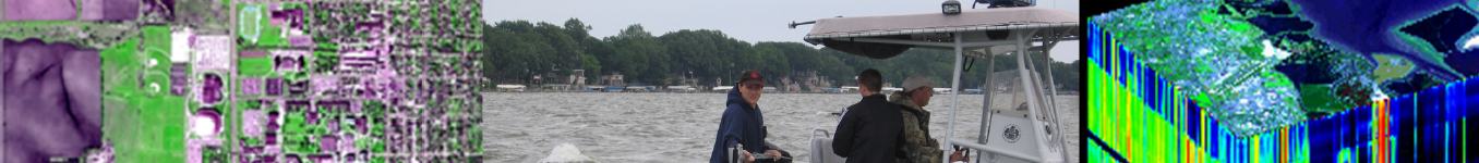
HI opens new opportunities for studying urban and transportation areas characterized by various spectrally distinct surface materials. Over the past several years, Dr. Liang, Dr. Ahn, and their colleagues have developed expertise in urban engineering and transportation applications using high and medium resolution multispectral as well as hyperspectral imagery and in construction management. Recently this group has been using hyperspectral imagery for studying transportation infrastructure extraction, urban environmental quality, urban land surface temperature mapping, heat island modeling, urban land characterization, and impervious surface classification.
Arctic Environments and Cryosphere Applications (Dr. Andrey Petrov)
The application of HI technology to study ice, snow and wildfires in the Arctic region are relatively novel, and has a great potential to improve our understanding of Arctic landscapes and impacts of climate change. Dr. Petrov has a long-standing expertise in studying polar and cold regions, specifically environmental and social changes associated with changing climate. The projects include hyperspectral remote sensing of ice, snow and other elements of cryosphere, as well as tundra vegetation, wildfires and human impacts on environment. Application of hyperspectral technology to study ice, snow and wildfires are relatively novel, and have a great potential to improve our understanding of Arctic landscapes and impacts of climate change. The Arctic, Remote and Cold Territories Interdisciplinary Center has access to state-of-the art equipment and high spectral and spatial resolution imagery.
Vegetation and Agricultural Applications (Dr. Andrey Petrov)
HI equipment can provide detailed reflectance/absorption spectral signature of individual species that can serve as their diagnostic tools, and thus are well suited for vegetation and agricultural studies. Dr. Petrov and his team developed a strong expertise in applications of GIS and remote sensing in vegetation sciences. Specifically, they have worked extensively on precision farming, yield prediction, crop residue estimation, and tree species discrimination using both multispectral and hyperspectral images. A large number of HI images have been collected over the past 10 year and will be available for IDRESHI students. The REU students will participate in collection and analysis of HI data and their integration with LiDAR and ground-based observations.
Water Applications (Dr. Maureen Clayton; Dr. Mohamman Iqbal)
Water quality is one of the most compelling environmental concerns in Iowa, where 55% of streams (a 25% increase since 2008) and rivers and 58% of lakes and flood control reservoirs were impaired in 2012 (a 23% increase since 2008); the draft 2014 report indicates a 15% increase in impaired waterbodies since 2012 (IDNR, 2012). HI can be applied to understand nutrient and water dynamics in terrestrial and aquatic ecosystems, to monitor the results of nutrient reduction practices, and to model the potential effects of climate change. For the past decades, Drs. Clayton and Iqbal’s group has been working with water-related applications such as water quality, wetland mapping and modeling, and contaminant transport. They have also become engaged in the HI analysis of water quality and contamination in Iowa Lakes. Ongoing research in this area is conducted with close collaboration between the Geography, Biology, and Earth Science departments. Their involvement in undergraduate education includes the development of an on-campus outdoor laboratory to study water quality in ground and surface waters including real-time data acquisition and remote viewing on a publically available website. Their studies have demonstrated the utility of aerial hyperspectral remote sensing in detecting and monitoring inter and intra-annual variations in chlorophyll, turbidity, and other water quality parameters.
Atmospheric Science Applications (Dr. Alan Czarnetzki; Dr. Xinhua Shen)
The use of remotely sensed data to examine the atmosphere including monitoring and predicting air quality has a long history. Recently, Dr. Czarnetzki and his team have been working with surface-based microwave radiometer to study the atmospheric boundary layer as it pertains to thunderstorm forecasting and air quality. Previous studies have included examination of remotely sensed aerosol measurements and modeling of particulate transport into Iowa. They have integrated satellite observations with surface data and developed a model for monitoring pollution levels. They are also working to understand the relationship between atmospheric mixed layer depth and particulate matter (PM) concentration.
Image Processing Improvement and UAS Applications (Dr. James Dietrich; Dr. Bingqing Liang; Dr. Patrick Pease)
The potential of HI for various field based applications will be restricted by several shortcomings that must be addressed through image processing. These drawbacks are related with the sensitivity to environmental illumination, the presence of noise in images, and selection of areas of interest, etc.. Hyperspectral image analysis and interpretation are further complicated by the large number of bands, presenting a challenge in image classification. All these issues must be addressed at different stages of digital image processing including atmospheric correction, image enhancement, image transformation, and image classification with advanced algorithms like object-based classification. Another solution is to incorporate ancillary data such as those collected by an unmanned aircraft system (UAS). With their low cost, semi-autonomous operation, and maneuverability in adverse environments except extreme weather conditions, UAS is emerging as a flexible alternative to collect sample data from near-space and can provide valuable input to HI. The UNI Geography Department owns one state of the art fixed-wing UAS aircraft and five cameras (three optical, one thermal, and one multispectral). They will be used to collect critical sample data in the real-time that will be invaluable to improve HI data analysis and interpretation for different field based applications including those mentioned above. In the recent two years, Dr. Dietrich, Dr. Liang, Dr. Pease, and their colleagues have gained much experience in working with UAV mission planning and platform/sensor selection and integration as well as the data processing.
Physics / Chemistry Applications (Dr. Tim Kidd)
Dr. Kidd and his colleagues are leading a research effort into the development of new forms of low dimensional materials of interest for electro-optical or electro-magnetic applications. The materials of interest are nanocellulose composites, electronically and magnetically doped transition metal dichalcogenides in bulk and 1D nanostructure form, and a new method developed using electron beam radiation to form nanostructures on layered materials. Attempts are being made to determine how electronic and magnetic properties can be tuned by introducing specific dopant materials to dichalcogenides. It is of interest to determine how doping and/or constraining film thickness alters the optical properties. Nanostructures formed on layered matierals are highly optically active, showing sufficient absorption in the visible wavelengths such that structures only 2nm tall are visible within an optical microscope. The aerogel composite materials are being developed to explore strength, the ability to incorporate magnetic materials, and tuning electrical conduction. It is of high interest to use spectroscopic methods to explore the homogeneity of these materials regarding the incorporation of different metals and other materials. Dr. Kidd and his research team have used HI for optical absorption mapping of new materials being developed with properties of interest for photovoltaic and other electro-optical applications. Optical reflection measurements will be used to determine absorption peaks and fluorescence properties in semiconducting crystals, thin films, nanocellulose composites, and nanostructures. Spatially resolved optical reflection data will be compared to spatially resolved stoichiometry measurements using EDX and also local structures measured with scanning electron, atomic force, and scanning tunneling microscopies to see if the chemical inhomogeneities truly affect the microscopic electrical, optical, and magnetic properties as well.
Geochronology and Soil Applications (Dr. Dennis Dahms; Dr. Patrick Pease)
Spectral imaging has proven useful in conducting rapid characterizations of sediment and soil. Lab-based hyperspectral data can provide a powerful analytical tool for analyzing sediment for which limited sample material exists. Often sampling strategies, such as extraction of cores from lake beds, provide limited material for subsampling and traditional analyses. Dr. Dahms and Dr. Pease along with their team are currently working to examine lake cores extracted from high alpine lakes in the Rocky Mountains which are frequently used in climate change studies. Recent studies analyzed cores in order to resolve spatial variation in core samples, ranging from mineral material to organic matter. Hyperspectral mapping prior to subsampling of the core can complement traditional analysis techniques by providing a new high-resolution data set and preserving valuable compositional data that can be further studied even after the core has been destroyed by traditional subsampling.
Geology Applications (Dr. Patrick Pease)
Traditional methods for identifying mineralogy in a sand population, such as point counting, XRF, or X ray mapping, are time consuming and expensive. Hyperspectral data with high spectral and high spatial resolution, collected continuously from 400 nm to 2500 nm, will provide the detail needed to distinguish common minerals in sand and allow for non-homogenized samples to be imaged at the individual grain scale. This would be a significant improvement over bulk analysis methods and be much less time-consuming than point counts. Likewise, satellite-based remote sensing techniques have gained popularity as a means to determine sediment and rock outcrop characteristics because of the advantages of collecting data rapidly over a large area. Ground-based verification of spectral results, however, is more problematic and often ignored. Collection of bulk spectral data in the field is subject to local conditions such as soil moisture, and the mixing of multiple surface covers, ranging from vegetation to lag, making detailed examinations more difficult. The ability to control for specific conditions in a laboratory setting and to move past bulk spectral data, will provide an improved strategy for calibration of satellite-based data for larger regional studies.
Computer Science Applications (Dr. J. Ben Schafer; Dr. Andrew Berns)
One of the challenges of working with hyperspectral imageries is related to high data volume and complexity in processing. Dr. Schafer, Dr. Berns, and their colleagues from Computer Science have been working with recommender systems, collaborative information systems, and agent assisted interface for the past 10 years. These are derived from the fields of information retrieval, artificial intelligence, and human computer interaction and are particularly useful for handling large volumes of data. Dr. Schafer, Dr Berns, and their colleagues have received funding support from various agencies including Google and Iowa Grow Values Fund.
